
Efficient agricultural planning and informed decision making are key elements for sustainability and resilience of agricultural production. To support this process Innovation Recommendation Mapping (IRM) was developed by Wageningen University & Research and experts from Ethiopia (mainly from the Ministry of Agriculture and Mekelle University) under the BENEFIT projects. IRM allows users to generate maps that show in which locations ‘best fit innovations’ can be scaled and what is needed to scale the innovations. IRM supports users to inform food security related decision making. In addition, IRM can support local level development planning, provide agricultural advisory services, and provide insights regarding priority setting for investments for local economic development. In complement, IRM can support monitoring and evaluation.
How does IRM work?
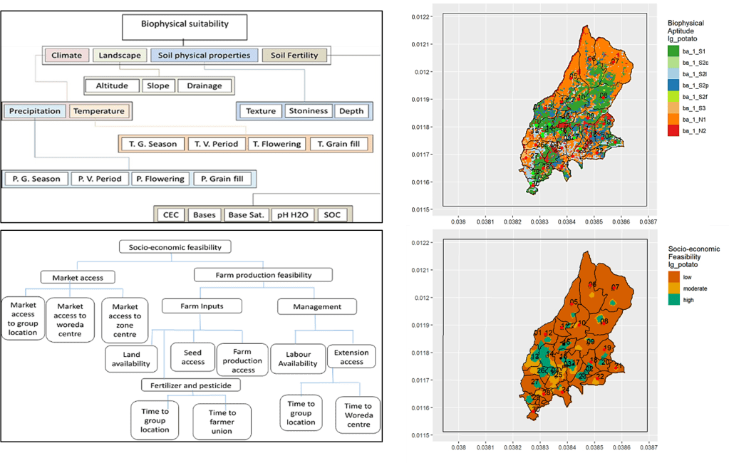
IRM is a modelling approach for geospatial, evidence-based decision support in agriculture, that can play a fundamental role in enhancing participation and guiding planning to make informed decisions and scaling of innovations to suitable niches. The IRM tool runs a GIS based multi-criteria evaluation that builds on the suitability of each innovation by matching agricultural innovations including their appropriate support packages with important biophysical, demographic, economic and infrastructural conditions related to specific geographical locations. The figure shows an example on how IRM was used in a particular area (locations in Table 1) to understand how biophysical factors affected the suitability for potato production and, in addition, how socio-economic factors affected the feasibility of potato production. The different colour coding in the biophysical aptitude map that IRM generates, indicate different limitations that affect the suitability of the area for potato, and provide suggestions regarding interventions that could address these issues. The socio-economic feasibility map, on the other hand, provides an indication on how access to market, farm inputs, extension services and labour affects the feasibility of potato in this specific area.
Existing experience with the application of IRM
The IRM tool has been used to scale best innovations in four use cases in major administrative regions of Ethiopia:
| Uses cases | What type of application | Location |
| Use case 1 | Biophysical aptitude for sweet potato (Hawassa 09 and Adu varieties) | Arsi and East Hararghe zones, Oromia |
| Use case 2 | Biophysical aptitude for maize (BH546 variety) and common bean (Hawassa Dume variety) intercropping | Silte zone, SNNP |
| Use case 3 | Suitability for wheat-faba bean rotation | Ofla, Endamekhoni and Alaje woredas, Tigray |
| Use case 4 | Suitability for Irish potato (Belete variety) | Lay Gayint Wereda, Amhara |
Use cases 1 & 2 are based on biophysical analysis, whereas use cases 3 & 4 are based on full IRM involving both biophysical analysis and socioeconomic feasibility.
IRM within RAISE-FS
Efficient and sustainable agricultural production is one of the outcome areas within RAISE-FS project. In this outcome area RAISE FS is working on exploring and promoting evidence-based innovations on sustainable agricultural practices, improved functioning of input supply chains and strategic planning for agricultural development. As part of the innovations to improve strategic planning and create better enabling environment, RAISE-FS is working on improving IRM in various stages of pilots in 2023 and beyond. The table below provides an overview of the pilots where IRM will be utilized:
| Pilot | Description of IRM Pilot |
| Pilot 1 | IRM for planning and scaling (suitability) on the ground of already developed sweet potato, and intercropping of Maize & haricot bean technologies and practices |
| Pilot 2 | IRM application for mapping of socio-economic and climate related vulnerabilities (frost, pest and disease) in specific geographical areas |
| Pilot 3 | IRM development for new crop (soyabean) and generation of advisory support within commercial food systems (for example tracking of the quality and quantity of production; planning logistics (inputs and outputs) and assessment of agro-climatological risks. |
| Pilot 4 | IRM for bottom up woreda planning (assessment and quantification of fertilizer demand and development of user friendly dashboard for visualisation of decision making impact) |
The continuous development of IRM applications involves multi-stakeholder engagement including the RAISE-FS team in Ethiopia, Wageningen University and Research, and the local team in Ethiopia (MoA, EIAR).
